Enregistrez gratuitement cette image
en 800 pixels pour usage maquette
(click droit, Enregistrer l'image sous...)
|
|
Réf : T02656
Thème :
Terre vue de l'espace - Iles - Récifs (286 images)
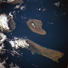
Titre : Molokai, Lanai, Hawaiian Islands July 1997
Description : (La description de cette image n'existe qu'en anglais)
Molokai, Lanai, Hawaiian Islands July 1997 The Hawaiian Islands of Molokai (long narrow island) and Lanai (near the center of the image) can be seen in this east-looking view. The island of Molokai is 40 miles (64 km) long and 7 miles (11 km) wide, and covers an area of 261 sq. miles (676 sq. km). The island, volcanic in nature, is generally mountainous. Kalaupapa Peninsula, located on the north side of Molokai near the left center of the image, is accessible only over a 2000 feet (610 meter) high mountain pass. It is on the Kalaupapa Peninsula that Father Damien, a Belgian Missionary, established a government leper colony in 1860. Today, along with increased tourism, Molokai has many cattle ranches and pineapple plantations. The island of Lanai covers an area of 141 sq. miles (365 sq. km). For many years, the island was used for sugarcane raising and cattle grazing. In 1922, the entire island of Lanai was purchased by a large pineapple company, which has developed the island into a pineapple-growing center. Cut by the top of the image, the western tip of the island of Maui can be seen
|
|

